Cairns and there significance
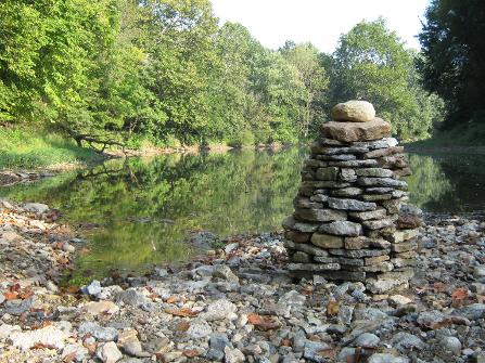
This is a Cairn I built in September 2009
I'm revisiting the Cairn for some reason inspired by a book I'm reading and when visiting Scotland I saw a book highlighting three Cairns called the 3 Brethren near Selkirk I didn't even know about.
I came across this photo I took a few years ago; I was walking by the river and saw all the stones at my feet. They inspired the building of a Cairn.
I didn’t have insight to the segnificance of a Cairn so did some research.
It is a mound of stones erected as a memorial or a marker to remember a person of an achievement in life, used as a visual landmark of something of significance that has happened, and will continue to have a lasting impact in a persons life.
I believe God try’s daily to get your attention to make a visual landmark or goal to press toward, and if we falter, we have that place to fall back too and pick up the pieces and relaunch into all God has for us to enter into having a visual aid as we do at times forget so easily what we are trying to attain or achieve for the kingdom of God. You may not build a Cairn, you can however, write a goal, keep a photo, or a magazine clipping before you as a visual reminder of that personal aspirations you are we press forward to achieve, knowing with God at our side we can blaze new paths.
My Blog or ramblings
My Pinterest
Walk of the week: Three Brethren, Borders
AT THIS time of year, brilliant views are to be had when mist stays glued to the valley floor well into the day and if you walk up the hills you can emerge to clear blue sky with summits poking up through a sea of fluffy clouds.
I was lucky to experience this on the Three Brethren in the Borders last week. With the Southern Uplands emerging through the white blanket, you feel you are experiencing something extra special.
This is a brilliant winter walk, but wear full hill-walking gear as you are covering a good distance and reaching exposed ground. The first section takes you through forestry then paths take you over open moorland with extensive views. From the summit, the Eildon Hills above Melrose catch the eye. The three 9ft cairns that tower over the trig point were erected at the start of the 16th century by the lairds of Yair, Selkirk and Philiphaugh to mark the boundary of their land.
The return takes you through more forestry interspersed with clear areas where you can look over the rolling hills.Finally, you will reach the River Tweed (near Ashiestiel Bridge) and a lovely stroll through the Yair House estate. Don't wait for low-lying mist as this walk is good any day when you can look out from the summit.
DISTANCE 9 miles. HEIGHT CLIMBED 1,300ft. TIME 4 to 5 hours. MAP OS Landranger 73. PARK At the Lindinny car park, just before Yair Bridge. It is on the A707, 4 miles from Selkirk.
IN SUMMARY Follow a path up into woodland on the left-hand side of the car park. After 50 yards go straight on, ignoring a path on the right. When you reach a bench the path bears right to a forest track, where you go right.
Keep on the track until a "3 Brethren Trail" marker indicates another track on the right that drops down to the left, then another path joins from the right before you pass a pond.
Continue uphill to a turning area and follow a marker left. This bears right and reaches a track you cross. Continue up a path on the other side. At a Southern Upland Way signpost go right and follow a path to the summit. Go left at the top, following a sign for Traquair. After a few hundred yards follow a "3 Brethren Trail" marker post right, down to a track where you go right again.(Note: forestry work may cause signed diversions. Ring 01750 721120 to check.)
At a junction go sharp left, almost doubling back. Then, a few hundred yards on, ignore a track going left and continue down. Carry on for 2 miles, right round Craig Hill, keeping to the main track and following marker posts. The track goes sharp left at the end of the forestry and past a metal barrier.
A couple of hundred yards further on go right, through a gate and follow a track. This joins the River Tweed, swings off through some forestry, then passes between fields.
You eventually reach a large beech hedge on the right; after this go left on a minor road and cross a bridge. Pass a farm and continue on the road to Yair Bridge. Don't cross the bridge, the car park is about 50 yards along the road (beware of the traffic).
REFRESH Try the Philipburn Country House Hotel by the A707 on the edge of Selkirk.
WHILE YOU ARE IN THE AREA Two miles east of Peebles, off the A72, is Glentress Forest, Britain's mountain biking capital, with a shop and caf too. (01721 721 736, www.thehubintheforest.co.uk).
• This article was first published in Scotland on Sunday on 22 November 2009.